The current Abbey Nature Preserve has two tracts totaling 63 acres off Scotts Hill Loop Road under the stewardship of the North Carolina Coastal Land Trust. An additional 65-acre tract adjacent to Poplar Grove was sold to Mungo Homes and is not protected by a conservation easement. This tract sits directly between the mill pond in the Abbey Nature Preserve and Poplar Grove’s manor house, once connected by a farm road that led all the way to the sound.
The 14-acre tract of Poplar Grove Historic House & Museum is also under the stewardship of the North Carolina Coastal Land Trust, a conservation easement that was entered into in 2009 to adjoin the Abbey Nature Preserve. Click here to view: Poplar Grove North Carolina Coastal Land Trust Conservation Easement.
For more information visit: https://coastallandtrust.org/lands/abbey-nature-preserve/ & Pender County to operate and maintain Abbey Nature Preserve | Pender County Government (pendercountync.gov)
A copy of Joseph Mumford Foy’s 1857 Peoples Pocket Diary lists the fields of the plantation by name, including Bowen Field, Old House Field, Mill Field, Long New Ground Field, Alligator Field, Lilaput Field, and Fox Neck, among others.
Poplar Grove was originally owned Ann and James Moore, Commander of the Whigs in Moore’s Creek campaign, 1776. Visit Moore, James | NCpedia for more information. The property was purchased by Cornelius Harnett in 1767 as his second plantation home on Topsail Sound to escape the mosquitoes of the Northeast branch of Cape Fear River where his primary residence, Hilton, was located. After Harnett’s capture by British forces and subsequent death in 1781, it was then awarded and/or confiscated by Francis Clayton who had served as Harnett’s secretary on the Wilmington Safety Committee, and later discovered to be Tory spy and traitor to the Patriot cause.
Upon the discovery of Clayton’s betrayal, Poplar Grove was listed again for sale on January 10, 1791 “where Mr .Clayton usually resided (formerly Mr. Harnett’s) containing about 800 acres, with a commodious dwelling house and other necessary buildings. A considerable part of this is clear and under good fences, having been planted this present year, and is excellent for corn and indigo: with this, or separate, will be sold an extensive range of banks, between the Sound and the Sea, esteemed valuable for stock and the timber, and on which is some good plantable land” (See advert below). This plantation site and another of 1,920 acres included 40 enslaved persons at this time.
The plantation and “lands of the sound ” was then purchased in 1795 by James Foy, Jr., son of Captain James Foy, Sr., who had served in the American Revolution and part of James Moore and Cornelius Harnett’s circle of American Patriots residing along the coastal communities between Topsail Sound and New Bern, Edenton and Bath, and the river plantations from Moore’s Creek to Fayetteville, along both branches of the Cape Fear.
The fields of Poplar Grove were under the constant care and skills of enslaved people known as the Gullah Geechee, West Africans purchased and shipped first to be “seasoned” in Jamaica and Barbados before being sold again to British colonists to work the lands along the Cape Fear River circa 1720 to cultivate rice, indigo and the naval stores of the pine forests.
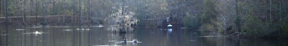
High and dry trails wind down toward a mill pond. The mill pond serviced the original plantation home of Cornelius Harnett, and was integral in building the manor house at Poplar Grove in 1850 after the original homestead was burned in 1857 from disuse. (See The Peoples Pocket Diary 1857). Two original mill stones are at the base of the damn. Note its tabby mixture. You will also discover tabby on the Smokehouse at Poplar Grove.
A short walk will take you on a return trip up the sandy road parallel to Scotts Hill Baptist Church. A longer walk will take you across the dam to double back through the woods along the outflow stream to return along the sandy run.
A wooden walkway built across the pond connects with walking trails on both sides to complete a loop across the dam, through the woods, across the bridge, and through the woods once again to join the main loop.
The Abbey Nature Preserve is not owned or operated by Poplar Grove. The entrance and parking for the Abbey Nature Trail is on the north side of the Manor House at Poplar Grove. While accessing the trails, please leash your dog before entering the forest across from Poplar Grove’s livestock stables. While on the trails, use the garbage bins to dispose of pet waste and personal trash.
Old Forest
A wide range of woods along the sandy road that leads back to the pond is an old-growth mixed of deciduous forest: Oaks, Longleaf Pines, Dogwoods, Magnolia, Cedar, Tupelo, Sweet Gum and Red Maple. American and Yaupon Holly, numerous Bays, Hawthorns and Wax Myrtles comprise the understory.
New Forest
Fields that were once planted with soybeans, sweet potatoes, peanuts or corn lay unused, and have begun an orderly and predictable journey through a succession of growth, from broom sedge and small herbaceous plants to broom sedge with woody plants that include cedar, pines, hawthorns, and oaks. The fast-growing pines will dominate and eventually be replaced by hardwoods. The climax forest is likely to be mixed deciduous with mature long leaf pines
Bottomlands
Scotts Hill Creek runs through the property, and was dammed about 150 years ago. There is a pond of approximately 10 acres and the water power from the pond once turned a set of millstones to grind grain. The outflow of the creek flows into Foy Creek on the south side of Scotts Hill Loop Road, and then further on joins Futch Creek. The principal tree around the pond is cypress, and along the creek are numerous old and large cypress trees. The old forest is along the top of a sandy ridge and is quite dry with its own set of plant and animal life particular to dryland forests.
The wetland forest is naturally different with another set of unique plants. But is it a wetland? Or is it merely wet land? The obvious wetlands of the Abbey Nature Preserve are more aptly called “bottomlands,” because they’re in the flood plain alongside the creek that runs through the property. This area of the coast is unique. The elevation along the land that lies back of and along the Intracoastal Waterway, a high berm – varies between approximately 15 and 30 feet above sea level.
The further inland one travels, the less the elevation, so that 15 or 20 miles inland, the high ground is likely to be only 10 feet or less above sea level. The low land behind the coastal ridge is characteristic of a “pocosin” or “Carolina Bay” – sandy and dry areas containing many elliptical peat bogs, with each type having its own forms of plant life. Wiregrass savannas and mixed longleaf pine and hardwoods give way to bogs plants and pocosin pines. The Manor House at Poplar Grove lies along the crest of the coastal ridge, the high ground that made foot and wagon travel dry and reliable in the early days and coincide with the route of present day Highway 17.
Confederate, or Yellow Jasmine
Dense foliage in a surprising range of color with bright yellow flowers. Often among the earliest bloomers in spring. Native, wild, and often domesticated along a fence or wall.
Sphagnum Moss
What’s the difference between peat moss and sphagnum moss? They are the same thing – sphagnum moss when it’s live, peat moss when it’s dead. In a bog, live sphagnum moss grows on the surface of large deposits of dead moss.Peat moss is mined by scraping away the top layer of living moss plants, and the layers of dead plants are dug out and dried. Really old peat moss bogs have compressed over time into peat, which is sufficiently dense, once cut out of the bog and dried, to be used as fuel. Even older peat, compressed over even longer periods of time, is transformed into soft coal.
Fields
Once planted in rotating crops of corn, peanuts, sweet potatoes, watermelon and turnips, this section of the Abbey Nature Preserve was once a part of the fields of historic Poplar Grove Plantation, which was prosperous during a time when most Southern farmers were facing economic hard times due to declining crop yields as well as declining cotton prices. Since the plantation did not produce cotton, but rather food sources listed at the top of the paragraph, food production in the fields remained steadfast with peanuts becoming a more locally outsourced crop after the Civil War. The fields at Poplar Grove continued the very same methods of crop cultivation through WWII from the skills of tenant farmers who descended from the original enslaved population of the 1860 US Slave Schedule.
The fields were often not farmed continuously, but allowed to rest, or “fallow.” Below is a field that was once planted in peanuts and now in the early middle stages of plant succession. The grassy field is populated with pines, young oaks, and red cedars.
For more information about the Abbey Nature Trail, please visit NC Coastal Land Trust.